Wanapum Dam - Hydroelectric Project Information

General Information

Dam:
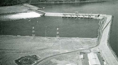
Wanapum Dam. Columbia River. River Mile 415.8
Constructed:
1959
Power:
1963
Owner:
Grant County PUD No. 2
Normal Full Pool:
570.0 feet
Normal Low Pool:
560.0 feet
Powerhouse Capacity:
1221.6 MW total1

1 From Grant County PUD.

Additional Information

Contact Grant County PUD No. 2 for all additional information.

Wanapum Dam

These web pages provide information about the location, construction date, pool elevation, and powerhouse capacity of the major federal and non-federal hydroelectric projects in the Columbia Basin. All information is courtesy of U.S. Army Corps of Engineers, NWD unless otherwise noted. The information and images are from the Army Corps of Engineers 1989 publication, "Columbia River and Tributaries Review Study: Project Data and Operating Limits" unless otherwise noted. USACE makes no warranties concerning the accuracy, reliability, or suitability of the data for any particular purpose. Pages include links to the owners/operators hydroelectric project web sites with visitor/tour information and further information. The map and these web pages cover only the major federal and non-federal dams in the region.

Photos presented on these pages of the individual hydroelectric projects have been provided by various sources. Images from USACE Digital Visual Library are Public Domain images and have been cleared for public release. The USACE provides them for your use for free. Where appropriate, please give credit to "US Army Corps of Engineers." Use of all other images should be cleared through the image provider.

Columbia Basin Research provides these web pages for informational purposes only. Columbia Basin Research is not affiliated with any hydroelectric project. Please contact the Owner/Operator for questions about operations, tours, and any other matter.