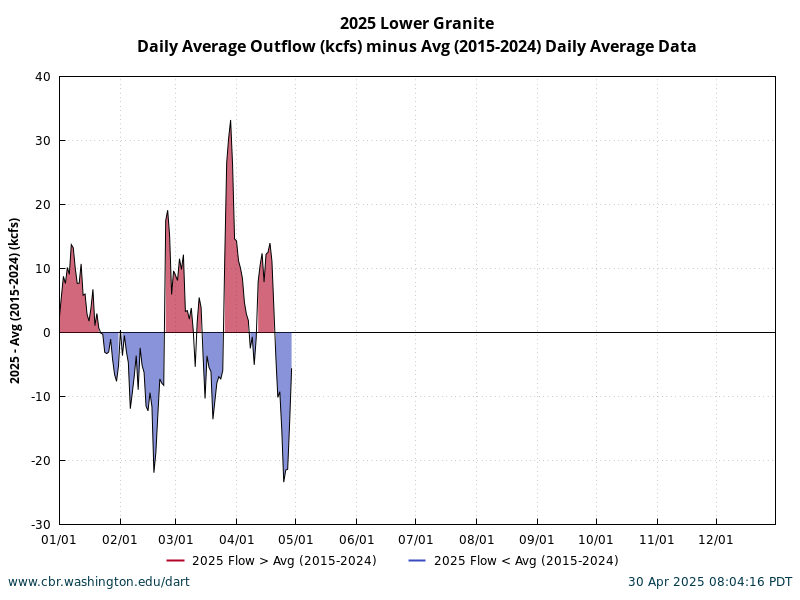
Data Courtesy of U.S. Army Corps of Engineers, NWD and Grant County PUD, U.S. Geological Survey Water Data, U.S. Bureau of Reclamation Columbia-Pacific Northwest Region Hydromet Columbia Basin Conditions Queries Basin Single Year Basin Year Comparisons Project All Years Project Year Comparisons Set Comparison Year Type N Year Average Single Year Make selection for Comparison Year Type before other selections. Select Year, Location, River Data, Comparison N Year Average Year 2026 2025 2024 2023 2022 2021 2020 2019 2018 2017 2016 2015 2014 2013 2012 2011 2010 2009 2008 2007 2006 2005 2004 2003 2002 2001 2000 1999 1998 1997 1996 1995 Location ALF-Albeni Falls Forebay [1961] ANQW-Anatone WA (Snake) [1999] BON-Bonneville Forebay [1949] CCIW-Cascade Island (Columbia, below BON) [2004] CIBW-Boundary (Columbia R US/Canada) [1997] CHJ-Chief Joseph Forebay [1960] CHQW-Chief Joseph Downstream [1997] CWMW-Camas/Washougal WA (Columbia) [1995] DWR-Dworshak Forebay [1973] DWQI-Dworshak Tailwater [1993] GCL-Grand Coulee Forebay [1960] GCGW-Grand Coulee Downstream [1997] HGH-Hungry Horse Forebay [1960] HGHM-Hungry Horse Tailwater [1998] IHR-Ice Harbor Forebay [1961] IDSW-Ice Harbor Tailwater [1995] JDA-John Day Forebay [1968] JHAW-John Day Tailwater [1995] LEWI-Lewiston ID (Clearwater) [1997] LIB-Libby Forebay [1975] LGS-Little Goose Forebay [1970] LGSW-Little Goose Tailwater [1995] LWG-Lower Granite Forebay [1975] LGNW-Lower Granite Tailwater [1995] LMN-Lower Monumental Forebay [1969] LMNW-Lower Monumental Tailwater [1995] MCN-McNary Forebay (Washington) [1956] MCPW-McNary Tailwater [1995] PAQW-Pasco WA (Columbia) [2000] PEKI-Peck ID (Clearwater) [1997] PRD-Priest Rapids Forebay [1961] PRXW-Priest Rapids Downstream [1995] RIS-Rock Island Forebay [1964] RIGW-Rock Island Tailwater [1997] RRH-Rocky Reach Forebay [1962] RRDW-Rocky Reach Tailwater [1997] TDA-The Dalles Forebay [1960] TDDO-The Dalles Downstream [1997] WAN-Wanapum Forebay [1966] WANW-Wanapum Downstream [1995] WRNO-Warrendale OR (Columbia, downstream BON) [1996] WEL-Wells Forebay [1967] WELW-Wells Downstream [1998] River Data Dissolved Gas Percent, Daily Average Outflow KCFS, Daily Average Temperature C, Daily Average Compare 5 Year Average 10 Year Average 20 Year Average